
February 4, 2026 BHS2026-06
Bayhorse Silver Inc, (BHS: TSX-V, BHSIF: OTCQB, 7KXN: FRANKFURT) (the “Company” or “Bayhorse”) is pleased to announce results from the recently completed IP Survey over its Idaho Pegasus Porphyry Copper Project, adjacent to its Bayhorse Mine Property that was completed in January 2026.
Figure 1. Pegasus IP/AMT chargeability inversion model at 300m below topography overlaid on the 2024 VTEM survey showing the claim boundaries and its proximity to the Bayhorse Silver Mine (center left).
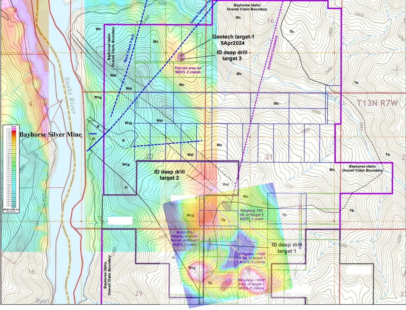
These results follow up the VTEM results announced in March 2024 (BHS2024-06) and the subsequent geological mapping program (figure 6) conducted by Dr. Clay Conway, P.Geol., on the porphyry copper potential of Pegasus, announced in September 2024 (BHS2024-18).
Bayhorse CEO Graeme O’Neill comments, “We are very excited to receive the results of the Pegasus IP survey. These confirm the presence of high chargeability, highly conductive and low resistivity targets lying in the southern half of the almost 4 square miles Pegasus Property. The area mapping by Dr. Conway showed the expected silver/antimony/copper/zinc mineralization as well as anomalous gold.” He further comments, “Based on the characteristic of the silver mineralization and the hydrothermal breccia intercepts encountered in the Bayhorse Mine 335 m drill hole in 2024, Dr. G.E Ray, P. Geol, believes that the Bayhorse Mine mineralization is epithermal in nature and that as gold values associated with the silver up to 10 g/t were reported during prior mining operations at the Bayhorse Mine, (Silver King Mines, 1984), gold values may increase at depth.
The Pegasus IP/AMT results compare favorably with the earlier VTEM results showing the low resistivity areas in blue (figures 2-5) that extend 1 km or more along strike and at least 550 m down to sea level. This anomaly may mark an eastward extension of the Bayhorse Mine silver-rich mineralization because initial indications from the IP/AMT survey show strong similarities to that at the Bayhorse Mine (BHS2026-03).
The SJV Geophysicists Interpretation Report states that the AMT model shows conductive zones extending beneath a conductive surface layer that is approximately 300 m thick. Beneath this layer, discontinuous north-south-trending resistive zones occur in the central grid area. Of particular interest is the southern central area, where a resistive surface zone overlies elevated chargeability at depth, forming a geophysical configuration analogous to the Bayhorse Mine mineralized response.
Thus, the Pegasus grid exhibits several geophysical features analogous to those observed at the Bayhorse Mine, including similarly oriented resistivity lineaments and chargeability anomalies beneath resistive surface zones.
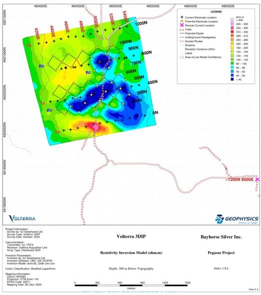
Figure 2. Pegasus chargeability depth slice at 300 m below topography highlighting moderate chargeability anomalies (blue) at depth.
A further IP survey will be conducted on the northern section of the Pegasus Property as soon as weather permits. Initial exploration drilling is planned on the five identified Pegasus drill targets, and further drilling will occur following positive results.
Recommended follow-up work at Pegasus includes:
- Explore the southern-central target area, where resistive surface units overlie elevated chargeability at depth.
- Extend DCIP and AMT survey coverage to better constrain the significant anomalies at the current grid boundaries and expand the grid to search for additional targets.
- Integrate structural interpretation to identify thrusts, splays, and potential rhyolite-related structures.
- Complete the remaining part of the planned grid to the north.
The Bayhorse Mine Rhyolite, that hosts the Bayhorse Mine mineralization, extends from the Bayhorse Mine on the west bank of the Snake River in Oregon, across to the Pegasus Property into Idaho and extends a minimum 45 km to Cuddy Mountain in the north, where Hercules Metals recently announced significant gold values when drilling on their porphyry copper discovery.
The Pegasus exploration model holds that the mineralized rhyolite could have its source in underlying shallow granites that may have porphyry copper potential as reflected by the low-resistivity anomalies. Pronounced low-resistivity anomalies lie beneath the mineralized rhyolite at both the Bayhorse Mine and at the Hercules Metals Corp’s property lying 45 km north of Pegasus. On January 15, 2025, Hercules reported drilling into a similar breccia in hole HER-24-20, which intersected rich copper-gold porphyry-style mineralization.
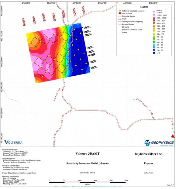
Figure 3. Pegasus 3D AMT resistivity model showing a conductive surface layer and resistive central zones, viewed from the south and looking north.
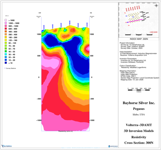
Figure 4. Section showing 3D inversion models resistivity extending from sea level to + 1,000 m.
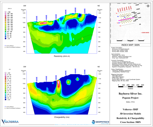
Figure 5. Resistivity and chargeability cross section.
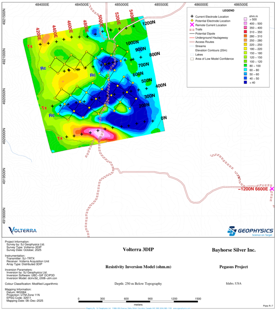
Figure 6 Pegasus 3D AMT resistivity model showing resistive features, with areas of elevated chargeability.
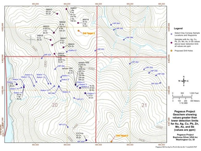
Figure 7. Mapping conducted by Dr. Clay Conway, P.Geol, 2024 showing surface sampling of anomalous gold, silver, copper, antimony, zinc on the northern section of the Pegasus Project. Also shown are initial drill targets.
This News Release has been prepared on behalf of the Bayhorse Silver Inc. Board of Directors, which accepts full responsibility for its content. Mark Abrams, AIPG, a Qualified Person and Director of the Company has prepared, supervised the preparation of, or approved the technical content of this news release.
On Behalf of the Board.
Graeme O’Neill, CEO